
China Cycling Travelogues
Do you have a China cycling travelogue you would like
to share here?
Contact us for details.
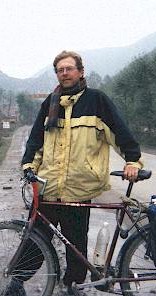
Rainer Mautz
Rainer Mautz@alumni.TU-Berlin.DE
Cycling Sichuan, Qinghai and Gansu
Email from the Road - Part 2
Copyright © Rainer Mautz, 2001.
Re: On My Way to Qinghai - September 17, 2001
One bad thing first: I lost one of your precious detailed Sichuan maps. May be it was a mistake of you to let me borrow them. Using the GPS I noticed, that the local people were always exaggerating with their town’s elevation. At one pass, I knew it was an elevation of 4,633m, but GPS was 230m less, showing only 4,400m. I calibrated the height again, and now I am fine. (that is the reason why our first pass was really 4,500m instead of 4,300m!
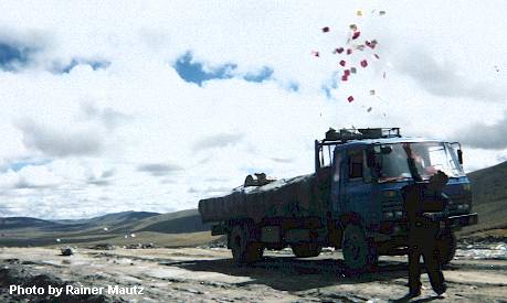
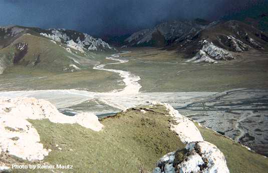
Throwing prayers in to the wind on Bayankala Shan in Qinghai
Province 300 km past Shiqu.
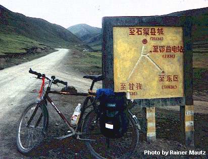
Mark was so right about saying that Shiqu will be tough! And how hard it got!!! Right after leaving Ganzi the road has no asphalt anymore, 90 km later at a junction called Maniganko the traffic follows Dege into Tibet. The road to Shiqu has almost no traffic. The area is all above 4,100 m! But sleeping at 4,300 m was no problem, since I am used to the height already.
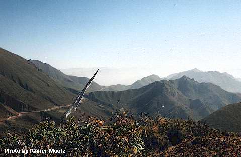
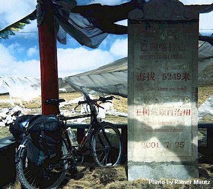
This is a , on top of a mountain. It is still quite early that day. I had an early start and reached the top at 10 a.m. 3,500 meters.
 But what was the really hard thing? The dogs! At the
last day on my way to Shiqu I suffered about 20 dog-attacks. Some would
follow me 2 km, sometimes four of them, one bit into my bag, causing only
little damage. When possible, I lifted my legs above my handlebars. I wanted
to quit, asking for a bus, but the Tibetans laughed at me. Bus? Every third
day only! On the day I reached Shiqu I cycled 130 km, bad road, two passes,
average elevation 4,300m, suffering my worst hell-storm (editor’s note:
I think he means hail storm) ever on a grassland plateau. Shiqu is the most
"luohuost" (editor’s note: I think he means "backwardmost"
from the Chinese words luo4 hou4 and adding the "st") place I
know in China, even no Wangba (internet caf?, no streetlights, electricity
only 4 hours a day...
But what was the really hard thing? The dogs! At the
last day on my way to Shiqu I suffered about 20 dog-attacks. Some would
follow me 2 km, sometimes four of them, one bit into my bag, causing only
little damage. When possible, I lifted my legs above my handlebars. I wanted
to quit, asking for a bus, but the Tibetans laughed at me. Bus? Every third
day only! On the day I reached Shiqu I cycled 130 km, bad road, two passes,
average elevation 4,300m, suffering my worst hell-storm (editor’s note:
I think he means hail storm) ever on a grassland plateau. Shiqu is the most
"luohuost" (editor’s note: I think he means "backwardmost"
from the Chinese words luo4 hou4 and adding the "st") place I
know in China, even no Wangba (internet caf?, no streetlights, electricity
only 4 hours a day...
In order to keep on living with two legs, I took a bus to Yushu this morning. At the main road there might be hope for a peaceful cycling. The only thinkable road is to Xining.
By the way: Yushu (Jade-Tree) is great...
*******
September 24, 2001 Arrived in Gonghe, Qinghai
Hi Peter,
I don’t know where to start with. The reason, why I didn’t mail you is simple: no internet between Yushu and Gonghe (where I am now). The GPS height was really wrong, as a surveyor I have a few words to say about that. GPS heights are ellipsoidal - they are simple geometric heights. But our height system, used in maps is related to the gravity field. In extreme mountain areas, these two systems have a big gap in between. The heights of the passes are usually shown by a sign (so was our Xiaojin pass), it is easy to calibrate the GPS height at such a point. Now the GPS goes quit along with the given heights.
Peter, it is funny, but I already bought such a "plumb bob". But the best way of keeping away of Tibetan Dogs is to carry two stones. If the first thrown stone doesn’t help, the second one always let the dog stop running after me. When I am cycling without stones, another dog might come, then the plumb bob comes into action. It looks, that the dogs know it well, once they have seen it, they let me go.
Now my progress from last week:
1. day: Yushu 3,900 m
2. day: past Xiewu at a Tibetan police station 4,300 m
3. day: middle of know where with a road-workers in their building 4,600 m
4. day: Qingheshui (dirty Tibetan place) 4250 m
5. day: Maduo (a Xiancheng, but so small, that there is nothing you could do) 4,300 m
6. day: Huashixia 4,100m ?
7. day: Wenquan 4,000 m (hot springs, but the dirtiest place I know in China)
8. day: Gonghe 2,700 m (big city)
I climbed Huashixia mountain and was rewarded
with great views all around (4,420 meters).
Today I cycled 190 km, starting at 7 AM, at an height of 4,000 m, climbing a 4,600 m pass in the morning, going down to 3,600 m, climbing another pass to 3,900 m. In Heka it was already 4:30 p.m. and I had to cycle another 80 km to here, but the prospect of a hot shower, good food and a wangba (internet caf? made it possible. The last two hours in the darkness were really enjoyable. Anyway there are no Tibetan dogs anymore, its a desert with sand, nobody living here in between the places.
I should have brought my map to the wangba, now I am not sure about the heights and places and names. The highest pass was 4,880 m, also everybody says, that the pass is 5,085 m (and a sign at the pass says so, but it actually refers to the height of a nearby mountain). Riding at such elevations was absolutely no problem, since I have gotten used to the height. Of course I couldn’t cycle so fast, but sleeping, eating and feeling was normal.
The road was a big deal: only one construction area, but it was 300 km long! Next year, the road will be paved, but now it is incredibly bad. (remember the last 20 km before Danba). Ten thousand road workers greet you; a heavy task to greet them back.
Food since Yushu: only Muslim food, Lamian (hand-pulled noddles) with goat meat and two Mantou (steamed bread).
Weather: changing within minutes, sudden winds, changing direction, sudden thunderstorms, ice storms. Morning everything is frozen, daytime can be very hot, if the sun comes, if not it stays about 0 C. Since the air is thin and dry, you don’t feel the cold so much.
good night,
Rainer
*******
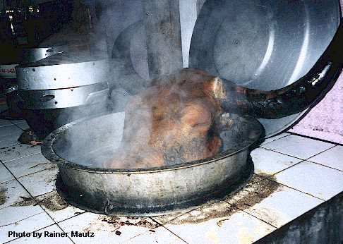
Cooking a whole yak head.
September 25, 2001 Gonghe
Hi Peter,
Of course you can post my emails and publish them anyhow. Now I am carrying my map, so I can report a little more detailed: Starting in Yushu: I just wanted to go, when I found out, that my gear-cable was cut (when riding on that lorry). I let a little xiu zixingche zhan (bicycle repair shop) repair it, with the effect, that he managed to pull out the wrong cable, but didn't manage to fix anything. Without any gears I rode around the town, ending up fixing both of them myself (me!) (editor: Rainer says this because he is notoriously lazy about repair his bikes. When we rode together, I ended up doing all his repairs except flat tires).
The first 100 km from Yushu and the last 200 km to Gonghe are paved. Really nice cycling from Yushu to Xiewu, all along the upper Yangzi (called Tongtian He), nice mountains, easy riding. After Xiewu came a big climb, lot of nomads. Many of them wanted to stop me, often in an unfriendly way. Often I saw them, carrying revolvers (guns).
On the other side of the pass there was no downhill. A headwind and a hell of a hailstorm forced me to wait under a bridge. The nomads nearby invited me for a butter tea (the butter is usually very old and so tastes the tea. But its nutritious should be rich.). The headwinds suddenly got so bad that I had to hide in an earthen hole (it was also raining). I got totally soaked and frozen I made it to a Tibetan checkpoint and ended up staying overnight there. Since the Tibetans were busy all the night, there was not much of a sleep.
The next night, near Qingshuihe was much better, staying with Han-Chinese construction workers. They all live in Xining and work from April to October, and are very bored out there at an elevation of 4,600 m. You can imagine how welcomed I was.
The "5,000 m" pass, called Bayankalashan was no big deal, since I had to climb only another 300m. But the road construction was, I went through all stages of construction, only the last, finished stage was missing. For any biker going on that road: not before summer 2002.
The next night was Yeniugou, normal Tibetan village. For the next day, my expectations were much too high: on the map came up the Xiancheng called Maduo. But there was nothing I wanted: no wangba, shower, food ...
By the way, from Yushu to here I always ate Muslim cuisine: Lamian (nudels
[editor: noodles] with yangrou and two mantous).
The weather changes, usually very suddenly, and forces me to put on and
take off my clothes, sometimes 3 times in an hour. From one minute to another
a heavy wind might occur and the temperature (which I feel) falls about
15 degrees Celsius.
The next night after Maduo was Huashixia. Since I got there early, I climbed
a mountain, having an incredible outlook over the Qinghai mountains. All
directions had read views, the air is so clear, you can see mountains over
mountains and dream...
On the next day it really got very cold, head winds make you doubt, that
what you are doing might be senseless. Finally I got to the hot spring place,
but its dirty all around, no pools were dug. So I stared building my own
pool, in expectation to have a bath there. But I have not even finished,
when a group of Tibetans came and used my pool (even though the area was
huge). Washing their clothes and their yearly body washing didn't make the
water any cleaner. I wasn’t until darkness that I had the chance to
have a bath.
My 190 km day yesterday was great. My physical conditioning was all right, but it was mostly a psychological thing: if you really want to get to one place, you can get there much faster. Riding in the darkness was fun! In the moonlight, very view cars and desert all around.
Today I am enjoy relaxing, eating and to shangwang (use the internet).
Yours Rainer
Cycling Sichuan, Qinghai and Gansu: Email from the Road: Part 1 | Part 2 | Part 3 | Part 4 | Part 5 | Part 6
Bike China Adventures, Inc.
Home | Guided Bike Tours | Testimonials |
| Photos | Bicycle Travelogues
| Products | Info |
Contact Us
Copyright © Bike China Adventures, Inc., 1998-2012. All rights reserved.